Wednesday, February 9, 2011

Fox and Franz Josef Glaciers Part 1 (more pics to follow with better internet connection)

Internet in NZ is expensive and difficult to find!  In NZ internet services charge by the amount of data transfered, so surfing the web ends up being really expensive.  Because of this, I started writing many of my posts a little while back and have been trying to upload whenever I can find the internet, but I just will not be able to upload all of my pics.  I decided to upload most of the story and a few pics as I go along, but I will try to upload the rest later.

We had 3 main goals of sights to see along the West Coast: the Fox Glacier, the Franz Josef Glacier and the Punakaki or pancake rocks. Being the glacier fanatic that I am, I could not pass up an opportunity to see temperate glaciers. What is better? On the west coast you can enjoy the trees, ferns, and other greenery right alongside the glaciers!

Enroute to the glaciers we passed through the town of Haast.  Apparently there is more to the town than we saw (a gast station, small store, and a motel).  However, we really just wanted to take a break from driving and spend a few minutes on the beach.

My mom trying to hide from the cold winds on Haast Beach
The drive out toward the coast through the mountains was simply stunning. Everywhere we looked we spotted these gorgeous waterfalls. They seemed to peak out through the trees on the mountains for a short while before the water plunged down into some hidden pool or river. Some of the waterfalls were so close that they spattered out into the road!
The walk out to the glaciers was a bit amusing. Yes I know they are rather commercialized but there was literally a packed path almost all the way out to the glacier. I am used to traveling for hours over really rough terrain via hiking, boat, and/or helicopters in order to arrive at the mouth of a glacier. Okay, it felt a little like cheating. However, I was really happy to get to share the experience with my mom and show her a little bit of the majesty of these amazing features I have traveled to the ends of the earth to study.  The walk out to the glaciers was also lined with gorgeous waterfalls. Here are acouple:

Although there are many of glaciers in the mountains in the Southern Alps of the Westland National Park of the South Island's West coast (I believe it is something like over 100 glaciers), the Fox (Te Moeka o Tuawe in Maori) and Franz Joseph Glaciers (Ka Roimata o Hinehukatere in Maori) are among the largest and most accessible.  The Fox Glacier is currently 13 km long and the Franz Joseph is a whopping 20 km long!  The area is fairly well controlled and regulated in terms of where you can go (unless of course you spring for one of the many tours).  However, via the free tromping path you can get fairly close to the glacier's mouth.  It made for quite a few good pictures!

Okay, so sadly my internet is just waaay too slow to upload the pictures.  I am trying to use this USB 3G antenna that my mom purchased for internet.  However, the signal is so low, it just won't upload the pictures (yes, AND movies Jeevan). I will have to get back to you with the glacier pictures (and movies) later.  Sorry! Stay tuned for more!!!

Monday, February 7, 2011

The Adventure to Auckland Begins

My flight back to the states leaves the 12th of February – so I have about a week to get from south of the South Island to Auckland, which is about close to the top of the North Island.  Now that my work at the University of Otago is winding down, I hope to take this last bit of time and see as much of New Zealand as I can see! 


We rented a car and will head North up the West Coast from Dunedin to Auckland.  When we started our venture a few days ago, we headed out of Dunedin westward toward Queenstown – the adventure sport destination.  Due to the tourist-ey nature of Queenstown we decided to stay in the nearby Wanaka, which is still a bit touristy but yet is much smaller.  One of the roadside attractions while entering Wanaka is the Puzzling World museum.  For a fee guests essentially are mice in a giant labyrinth.  There are apparently tons of puzzles on the tables in the cafĂ© and several optical illusion rooms.  Although we didn’t actually pay to enter, we enjoyed watching people in the 2 layer maze and looking at the Leaning Tower of Wanaka!


The Leaning Tower of Wanaka!
We ventured around the lake on the little roads enjoying the brilliant blue coloring on road bikes and on foot!  It is really an amazing and unreal color.  I think these may be glacial lakes, which may explain the gorgeous coloring.  As the glaciers slide over the rocks, they grind the basal rock material into a fine powder, which reflects light in a really beautiful manner.  However, this is just my speculation of where the blue coloring comes from – I still need to do a bit more digging for this one! 

Snow Covered Peaks in the Distance!

Looking out over the lake
This was a river that flowed under a bridge that we rode our bikes over.  The colors were so pretty, pictures can't quite capture it!
The day we went out riding it was super windy.  The clouds were approaching lenticular shape (when they are really thin and spread out).  This only happens when there are really strong winds!
I love the rivers, they are so pretty.
We have a ways more to drive and New Zealand roads are crazy!  They are some of the most windy, narrow roads with huge elevation changes! We took what we thought was a shortcut over to Queenstown from Wanaka -- but soon realized that the "shortcut" was actually a mountain pass.  Our poor little rented Nissan was really struggling.
Whoooooa!!!
A scenic view on our "shortcut" over to Queenstown.
We spotted a bunch of goats climbing through the rocks on our way back to Wanaka!!
Goats!!  I think that says it all ... ;-)
Another Little Goat!
Next we are headed out and up the west coast hoping to find some tropical glaciers!!


Thursday, February 3, 2011

University of Otago and Dunedin!


The past several weeks have really flown by here.  My first week in New Zealand was spent working at the University of Otago in Dunedin where my adviser is taking his sabbatical.  My work in Otago is slightly different from what I was doing in Antarctica (and it is much more lab-based). 

While in Dunedin I am staying with my adviser who lives on Baldwin Street.  This modest little street’s claim to fame is that it is literally the steepest street in the world at a 35% gradient!  As we turned the corner to Baldwin after Yo picked me up at the train station, I was at a loss for words.  Pictures do not do it justice.  However, it is pretty funny to see the sharp angle of fences and houses that line the streets.
A cat on Baldwin Street, posed on a fence post,  Note the angle of the fence!

My mom standing on Baldwin St.
An extremely angled fence in front of one of the Baldwin Resident's homes

Gorgeous sunset in Dunedin from the top of Baldwin St.
 This past week my mother arrived to hang out with me a bit before her race in Taupo, NZ (she’s racing the ironman in about a month!)  This past weekend, we decided to get out of Dunedin a bit to visit the Moeraki boulders.  These rocks are truly unique.  They form as calcite concretions due to calcite precipitation around any bit of material such as a shell, piece of wood, or fossils, which acts as a seed crystal that encourages mineral precipitation.  Concretions by definition are sedimentary rock (ie. mudstone, sandstone, etc) that has mineral cement (in this case calcite) that forms between the grains.  The Moeraki boulders are up to 2 meters in diameter and commonly form calcite, and less commonly dolomite or quartz, veins throughout the boulders. 

It was interesting to hike up along the dunes behind the beach, where you can see partially exhumed boulder in the mudstone.  As the elements continue to weather the rock unit, the boulders will continue to roll out onto the beach!But yes, you are probably saying, “enough science now, I want some pictures!”

Not a boulder -- just a really pretty piece of seaweed attached to a rock that was washed ashore
A perfect sphere amidst the broken remains of many eroded Moeraki Boulders!

Perfect ball markers out to the sea
The top of this boulder eroded away and the bottom half is buried in the sand.  It actually looks a little bit like some type of alien eggs!

The interior of a partially broken boulder
A parting shot of the boulders
Finally, one of my co-workers at the University of Otago (affectionally called the "Uni") said that any trip to Dunedin is not complete without at tour of the Speight's Beer Factory.  Speights Beer is "the pride of the South" and is ubiquitous throughout the South Island! So, after work last week, we went to take a tour of the brewery.  It was actually pretty interesting to see all of the stages of beer brewing, from mineral spring (where speights gets the waters for its beer) to the bottle! 

Bags and bags of malt!
Giant copper basins to cook down the malt.
The beer barrel chimmney at the Speight's factory.  The story behind the tower is that the architect's assistant doodled a beer barrel on top of the smoke stack as a joke.  However, the architect unknowingly took the plans to present to Mr. Speights who loved the design!
This is a picture of an old picture of how the malt used to be stored.  At some point the factory had a really bad case of mice.  Cats were introduced to get rid of the mice, but the cats had kittens and continued to multiply!  Can you spot the kitten in this picture?


Saturday, January 29, 2011

Last field day out at the Cotton Glaicer

A lot has happened in the last month or so.  We had 2 more field days at the Cotton Glacier and then we had a hours and hours (did I mention hours!?) of lab work to finish processing the samples and get ready to leave the ice.  I safely made it out of Antarctica and to New Zealand about a week ago.  This week I have been working at the University of Otago, where my adviser is doing his sabbatical.

I have a ton of pics from our last couple of days out that I want to post, so I will attempt a narration about them so it doesn't just look like a random assortment!

The first set of pictures are from our second to last field day out at the Cotton Glacier.  We were collecting enough water to fill 2, 55 gallon drums and 6 20L carboys!  It was a lot of water.  Due to all of the issues with helicopter schedules and getting our gear and all of the empty carboys out to the field, we had the chance to ride out in the Kiwi helicopter (owned by New Zealand).  It's a pretty slick machine!

The Kiwi helicopter -- isn't it beautiful?  They have a contained back rudder and the whole front is a big bubble of glass.  It is so much fun to ride in!!
Once we arrived at the glacier, we went around checking out all of the monitoring equipment that we leave in the field from trip to trip.  The Cotton Glacier meltwater stream is an extremely dynamic system that changes constantly throughout the season.  We hoped to capture these changes using meteorologic data from a weather station, pressure transducers, stream gauging, and plant cameras that collect hourly time elapsed photos.  However, the system was rough on our equipment and we almost lost a lot of the gear.  The picture below is of the met station that was originally installed with about 1.5 feet of clearance before the edge of the ice.  By the end of the season, the ice had melted so much that the station looked like it was about to topple over the edge.
Our meteorological station before we took it down on our second to last field day at the Cotton.  The mountain in the background is called Sperm Bluff because the early explorers thought it looked like a giant sperm whale. 
 After we collected our enormous amount of water (the helicopter pilots are starting to wonder what we are doing with so much water -- they were joking that we started an underground business selling glacial melt water), we had some time to explore and take pictures.  A few weeks before (I didn't go out on this trip), the melt water channel almost completely filled with water.  Based on our plant cam pics, within a few hours of the team's short visit to the glacier, it began to drain and was completely drained by about 6 hours.  It was interesting to see all of the new channels and features that developed as the aftermath of this filling.

 A pretty large river channel through the surface of the cotton.  Just a few weeks before, this whole area was covered in water

 Awesome little sand structures Mike and I found on our walk around some of the sand dunes.  They look like tiny little sand cliffs.
An ice cave Mike discovered in some of his wanderings!
The helo finally picked us up to whisk us back to base.  It was quite a pretty ride home.  This was one of the waterfalls I spotted off the end of a glacier.
Now, the next group of pictures is from our last field day out at the cotton glacier.  Our goals for our last day out were to mostly recover all of our sensors (some were completely buried in sediment from the previous flood on the glacial surface).  When the helo came to pick us up, we were given a little bit of extra time to just fly around the system and get a better idea of what it looks like from the top to the bottom.  The next series of pics are from this recon time.

Columnar basalts on the top of Killer Ridge, which borders the upper part of the Cotton Glacier
Gorgeous blue ice peaking through the sand of the melt water stream in the upper Cotton Glacier channel
Penitene ice in an area of water ponding
Blue ice again in the melt water channel.  It is amazing to think, as we stand on the sand dunes that solid ice lies just below us.  These images of the stream always remind me of that fact and it continues to amaze me.
The lower section of the Cotton Glacier melt water channel
Interesting melting patterns of the ocean ice, taken as we flew back to McMurdo
I am not sure which mountain range this is, but again it was taken on the way back to base
The sun was striking the meltwater channels at a very nice angle

A beautiful sunset to end our last field day.  I took this pic from McMurdo as we headed to the dining hall to catch a late dinner.
Stay tuned for pictures from New Zealand!  I am finally finishing up my work at the University of Otago this week and am ready for a long awaited vacation!

Sunday, January 9, 2011

Camp Pull-out From Frxyell

I am a bit behind in my entries, since our Camp Pull-out from Frxyell actually occurred just before the new year, but I realized I have one more video (sorry I didn't take more Jeevan!) and a few more pics from our last day at Frxyell. 

At Frxyell, since the ice cover never completely disappears, we often traveled across the lake ice on four wheelers.  We travel across the moat (where the lake ice melts at the edge of the lake), by a small boat to our four wheeler.  It can be quite an adventure to get across the lake!  Contrary to what I initially thought, the lake ice surface is anything but flat!  Solar irradation, sublimation, refreezing of the ice causes the formation of trenches and piles of ice.  Much of the lake ice is composed of a particular ice known as penitentes.  These long blades of ice form with their long axis generally oriented to point toward the sun.  They make a beautiful tinkling noise when stepped on and sound a little like wind chimes!  You can kinda hear it in the video I took of Heidi walking in circles around me ;-).

We left Frxyell in a whorl wind of packing up labs, tents, and personal gear.  We have so much science equiptment (in addition to our personal gear), it took 3 helicopters to get us and all of our stuff out of camp!  The helo pilot of the last helicopter that came to pick us and our last load of gear up took one look at our giant pile of bags, shook his head, and said, "Wow, you can really tell that your group is all women!"  (We did have Mike with us as well, but we had managed to convince him to paint his fingernails with us for Christmas -- so I think he was including Mike in this assessment!).

 AStar-B2 Helicopter with one of 3 of our giant white boxes taking off with the sling load.

However, with 3 giant white boxes slung under 2 helicopters (2 stacked and then 1 single sling load), and a VERY full Bell 212 helicopter, we managed to pull out from Frxyell -- only forgetting a pair of hiking boots (not mine, I promise!).


Lake Frxyell from inside the Helicopter


Say goodbye to Lake Frxyell Camp!


Beautiful frost-heave pentagons

The frost-heave pentagons form due to the freezing and thawing of the permafrost.  I don't fully understand the actual mechanisms behind the formation of frost-heave wedges since there seems to be several different hypotheses and many important little details.  However, in short these often form in permafrost and are the result of the expansion of water as it freezes in a constrained setting.

The volcano, Mt. Erabus, taken from the Helo as we fly back to McMurdo

Since leaving Frxyell, we have been doing tons of lab work -- trying to process all of our samples, unpack from the field, and repack for our upcoming departure!  Two days after we returned to McMurdo, we headed out to the Cotton Glacier for our second to last field day out at the Cotton Glacier!  It was a blast to do --- I'll get the pics and more posted soon!

Monday, January 3, 2011

Happy New Years!

So we have been back in McMurdo for a few days now, working away to get all of our samples processed.  However, I was so busy while out at Frxyell (and the past few days), I have tons of pic I wanted to post ages ago!  To start off the new year, I thought I should clean out some of my back-log of pictures.

Before we headed out to Lake Bonney and Lake Hoare for Christmas, we were visited by the Santa flight!  This flight visits all of the field camps and brings a Christmas box with wonderful snacks that we don't normally get in the field -- among other things, our box had gourmet cheeses, fresh peppers, and grapefruits!!  We were all really excited for the "freshies"!!  The flight also gives some of the permanent McMurdo employees an opportunity to visit the field sites, which they otherwise would not get to do.  There was much anticipation to the flight and it was a lot of fun meeting everyone!
Santa Flight!

Next group of pics up is the Limnology Hole:

These are a couple pictures of the limnology drill hole (referred to as the "limno hole" here), which the Long Term Ecologic Research (LTER) project uses to study the chemistry and biology of lake Frxyell.  We had the opportunity to sample from the hole that Heidi will use to look at the microbial population of the lake to compare it to the supraglacial population of Canada Glacier that flows into the lake.

The hole doesn't completely re-freeze overnight, but with a few days of no sampling, a sheet of ice tends to form over the top of the lake water.  So to sample, you have to break up the ice with an ice chipper and then use the scoop to pull all the ice out of the hole (This is what Heidi is doing in the pic to the left).

The hole i actually quite beautiful.  The ice is so blue!  Below are just a few pics looking down through the lake ice...  


Looking down the limno hole

Close-up of ice at the top of the limno hole
To sample the hole we use a device called a Niskin water sampler (aka. Van Dorn water sampler).  The Niskin is basically a tube with spring loaded caps at either end.  When the sampler is lowered to the desired depth, we drop a weight down the feed line that triggers the caps to close.  That way we can collect water from different depths in the lake!


Our Niskin sampler going down the hole!
Also as promised, I wanted to post more pics from our hike on Christmas from Lake Bonney to Lake Hoare.  It was so much fun!  There were many amazing sights throughout the hike.  For a little orientation, below is a satellite image of the Taylor Valley with the major lakes and glaciers labeled.  We started at Lake Bonney Field camp (located about 6:00 on the image of the lake below) and hiked toward lake Hoare around the Seuss Glacier.  The day after Christmas, we hiked back over the Canada Glacier to our camp at Lake Fryxell!

Satellite image of Taylor Valley (Image From Wikipedia)
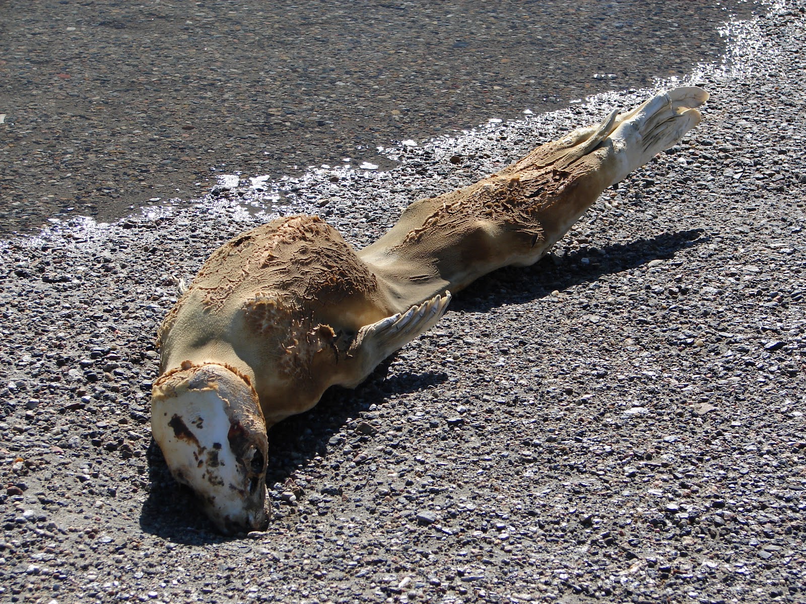
Throughout the hike way we saw 10 or so mummified seal carcasses, which are common throughout the valley.  Apparently, the seals come inland to mate, but get lost and instead of heading back out to sea, move inland.  They sadly eventually die of starvation and the carcasses are preserved for hundreds of years afterwards because of to the cold temperatures and dry climate.

A mummified Seal Carcass
Frost heave wedges forming organized cracks throughout the permafrost
A view looking up-valley toward the Taylor glacier

The glaciers pulverize the rock material into a fine dust which makes many of the lakes have a brilliant blue coloring

The edge of the Seuss Glacier looking toward Lake Hoar

The melting edge of the Seuss Glacier looking out back up Valley
Posing of Lake Hoare!!!  We made it!!