Tuesday, July 28, 2009

Thermokarst and Christmas!

So this has been a big week in terms of social activities here at Toolik! We celebrated Christmas a couple of days ago on July 25th! Leading up to Christmas was the ABC party (anything but clothes). The idea was to create an outfit out of found items. One of my friends, Shilo put together an amazing trash bag dress, complete with duct tape corset. She came over to the lab before the party to convince me to go and helped me put together a bench paper dress!
The 25th of July was Christmas. Everyone who wanted to participate put their names in a box for Secret Santa! We all made gifts out of found objects for the other person. It was pretty impressive how creative some people were! Examples of gifts included a moose attack survival kit, river dioramas, a puppy constructed out of cardboard tubes and springs, and even a sheep made from real sheep's fur! The person I was making my present for is really into puns so I did an online search for puns and collaged a 1-L square water bottle (which was really a washed out sample collection bottle) with all of the best (and worst!) puns that I found. I also added a couple of really funny cartoons. My favorite was an xkcd cartoon about the purity of sciences:
(from http://xkcd.com/435/)

I was pretty proud of how it turned out. Dan even dressed up as the grinch/santa and Scotty (one of the camp staff members) made a Christmas tree out of the midget willow branches!
I have a feeling this week was kind of like spring/winter weekend at Smith... or rather the calm before the storm! We are about to hit crunch period in the next few weeks. i can't believe I only have a month here left ...

~~~~~~~~~~~~~~~~~~~~~~~~~~~~~~~~~~~

Just so you all don't think that we are only partying around here, I felt the need to post about the thermokarst site where I helped Sarah measure thaw depth, soil moisture, and soil conductivity along 4 transects. Thermokarst refers to land features (commonly slumps, fractures, and other land failures) that occur due to the melting of permafrost (frozen ground). Measuring thaw depth basically requires pushing a large pole down into the tundra until it hits the permafrost. The problem is that the pole often hits rocks or gravel before it reaches the permafrost. Although the reverberation of the pole against rocks is significantly different than the pole hitting the frozen ground, it is often difficult to find points without rocks.
So much of the permafrost had melted out at one part of the land failure caused a large cave to form. Ice was actually exposed on the back wall and the overhang was almost solely supported by roots from the tundra plants and grasses!


Thursday, July 23, 2009

Sampling at NE 9B

This morning we went out to the lake NE 9B, northeast of Toolik to sample. Although I wasn't really needed in the boat, I went along for the hike. It was nice and cool this morning and about a half hour walk out to the site. I went and took pictures while they were sampling. Here are a few more flowers to add to my previous post:
This flower is known as the Frigid Shooting Star (Dodecatheon frigidum). This one is another member of my purple flower collection. I really like this one and hadn't seen this type of flower anywhere until today.

This is the Dryas flower, which is where the name for the Younger Dryas originated. Cores recording this glacial period contain abundant pollen of these flowers.

Dan and Shannon sampling out on the lake

Dan and Shannon had a little trouble with the dissolved oxygen probe while out on the water, so sampling took slightly longer than normal. I got bored and decided to do some tundra yoga!

Arctic chickens!

There was a little family of ptarmigans that hung out outside the lab for a couple of days. They were so cute! They look just like the arctic version of a chicken..

Wednesday, July 22, 2009

The Burn ... and the moose chase

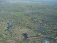
The largest recorded fire in Alaska occurred during the summer of 2007, when 256,000 acres of tundra ignited. There are several groups on camp that have started researching the regeneration of the land in the past couple of years and its effects on the land and water ecosystems. This past Sunday I went out with Cody to help with sampling and bathymetry of several lakes out at the burn site. Cody is studying the effects of the fire on lake productivity, so he was collecting water and zooplankton samples as well as several lake sediment cores to analyze sediment productivity. It took us about a half hour to arrive at the first lake we were sampling called North Lake. It was really cool to see the patterned ground from the air! Freeze-thaw action of the permafrost causes the land surface to break into polygons known as patterned ground. It makes the landscape look almost scaley (pic right). While we were flying over Horn Lake, we watched a moose wade across the water (I unfortunately didn't have my camera on the flight out, so I didn't get a picture of it, but I eventually met the moose later in the day, at a distance a little too close for my comfort level ...).

After the flight, we finally touched down at our first lake for the day. The tundra at the burn site is noticeably charred and the shorelines of the lake are definitely blackened from the fire. However, over the past couple of years, promising new growth has started, and now covers a significant portion of the charred ground.


We continued from North Lake to Horn lake where I would be responsible for mapping bathymetry of the lake. Cody fixed a little pinger on the bottom of the boat, which was connected to a GPS unit and tells depth at each point. Basically my job was to paddle back and forth accross the whole lake to map out changes in depth. It was a decently windy day and quite a large lake, which made the bathy mapping a really good work out! When I made it about half way across the lake, I spotted a moose on the far shore. He (or she?) wasn't full grown, but was definitely large. I thought, "well he's just on shore; I am okay with that." I continued mapping for another half an hour and the moose sat down in the tundra to watch me. However as I got closer to him, he suddenly stood up and then started getting in the water. My first thought was, "uh oh ..." and then he started wading accross the lake coming toward me. Now, the lake was really shallow--about a half meter deep in the middle of the lake--so although he couldn't charge, he could still probably trample me effectively. I immediately thought about the conversation we had in the helicopter on the way out about how more people have been killed from moose charging than grizzly bear attacks and I really wasn't about to test that statistic. As the moose continued toward me, I spun the boat and booked it back to shore. Although I was paddling against the wind, I paddled as hard as I could, and definitely gave it all I had left after doing all of the bathymetry mapping! Needless to say, he eventually lost interest in me and continued to the other side of the lake. However, I decided not to test him and pushed on back toward our launch point on shore.

Tuesday, July 21, 2009

Fish Tagging at the Kuparuk River

On Saturday I decided to tag along with Elissa and her assistants to the Kuparuk River to tag grayling fish. It was another beautiful day (we've had a fair few of these this week!) and I really didn't want to get stuck inside mixing reagents all day. We all trudged out in the tundra a few kilometers from the road to a deep section of the river to fish. Elissa and Max used fly rods and Aleah and I used the reel lines. Everyone had pretty good success catching fish (except for me that is). At the very end of the day, I hooked two fish, both of which sadly got away. However, together, the other three had around 8 fish to tag. After watching Max and Aleah tag a few fish, I gave it a try myself. I just felt really badly for the fish we tagged, but I decided to go ahead and learn the process. The fish were put in a bucket that had some chemicals in it to knock them out. Each fish was then weighed, measured, and then tagged. To tag the fish, we first used a scalpal to slice a shallow hole on the fish's ventral side just above the fins (pic left: Max tagging a fish). Then we had a large syringe that contained the electromagnetic tag in in. Each cylindrical tag is the diameter of a pill and around 2 cm long. To tag the fish, we inserted the syringe tip about 1 cm in the slit we made and depressed the plunger to insert the tag.

We returned the fish to shallow calm water for them to recover and wake up from the drugs. Gradually they would become responsive and swim away. Elissa uses the tagged fish to study the grayling migratory patterns. She has tagged fish at various points from the headwaters of the river to further down stream to track when the tagged fish pass underneath an antennae she set up downstream.
Max moving the grayling though the water to get fresh water into the fish's gills speeding the recovery process.

A recovering grayling post tagging

Sunday, July 19, 2009

Purple Flowers!

Upon request, I have been collecting pictures of arctic flowers. Although it was completely not on purpose, I realized that all of the pictures I have collected are of purple (or purple-ish -- maroon, violet, etc.) flowers! It was on accident I promise!


These two are pictures of Monkshood (Aconitum delphinifolium). This is one of my favorite flowers. They kind of remind me of an iris. This was an entire field of Monkshood flowers that we found by the Kuparuk while we were YOY fishing.


These two pictures are of the insidious fireweed (Epilobium angustifolium). Although not the state flower, it is by far the most common flower we have encountered here. It has a bright red stalk, yielding its name of "Fireweed." It is also commonly the first plant to inhabit an area after a forest fire!

The picture to the left is of Jacob's Ladder (Ploemonium pulcherrimum). This picture was also taken near the Kuparuk river near all of the Monkshood. I was told that Jacob's ladder is named due to its ladder-like leaf growth. However, I also read online that it was named after the growth pattern of the stalks, since each new growth is stacked upon the last one like a ladder... so who knows.


I am not sure what flower is in these last two pictures. I was told that it is coltsfoot, but when I looked it up online it appeared quite different from what other people are naming coltsfoot. It is pretty all the same. I will have to do a bit more digging to figure out what it is though!

I know this isn't a flower, but I couldn't resist adding this picture of red moss in. I just really like the vibrantly red color. This picture was taken during my hike last weekend to the Spoomerang glacier. The red moss completely covered some of the stream beds!

Friday, July 17, 2009

Inlet Sampling the Sequel

The last two days we sampled the inlet series of lakes for a second time. These lakes (referred to as the I-series) are sampled 3 times throughout the summer, which means that we have 1 more I-series to survive! The lakes are split into 2 days; the first day we sample I-lakes one through Six-HW and day two we sample the lakes six through eight and I-swamp. As I mentioned when I wrote about the first I-series we did this summer, although it is not an impossible distance to hike, we carry so much gear and collect such large samples of water we get to take the helicopter out to the site and then are choppered back from our last sampling location. My pack was so heavy by the end of each day, that I could barley lift it to get it into the helicopter. I had been so concerned about being airsick in the helicopter, but I actually really enjoyed our short rides through the air. It is awesome to see all of the lakes we sample from the air. It was also fun to see Toolik as we flew away!
Sampling went fairly smoothly both days we were out. The first day there was absolutely no wind at all, which is good and bad. The lack of wind definitely helps while we paddled out and attempted to locate the deepest point in the lake where we would sample. However, the lack of wind left nothing to discourage mosquitoes from swarming us and made the hot day feel even hotter. By late afternoon, when our packs were getting heavy and the hike between lakes is much longer, we were completely overheating. The field fashion for sampling includes tall rubber boots and long pants, both of which do not help when the sun is beating down on you! Dan and I decided that swimming was entirely necessary. So at Lake I-5, Dan and I jumped in the cool lake. It felt amazing after hiking all day in the hot sun. I didn't want to get out, especially since there was a cloud of mosquitoes waiting for us to get out of the water, but we only had time for a brief swim and then it was back to work!

The second sampling day was slightly more windy, especially at the first lake we sampled! Dan and I got out to the deepest point in the lake and the winds started kicking up. When we tried to drop our anchor, the rope got tangled and for the life of me, I couldn't get it un-knotted! I handed it over to Dan to work on and I started paddling into the wind to try to keep us from drifting. The wind had kicked up since we left shore and the waves were large enough to have white caps. It was quite an ordeal!


Wednesday, July 15, 2009

Spoomerang Glacier~!

This past Sunday I went with a group hiking up to Spoomerang glacier. The rain had finally given way to a beautiful (and hot) sunny day. The wind was pretty low, so a bug net was a necessity for the hike. We ended up actually summiting 3 times during the day. The initial hiking plan involved us hiking up Rouche Mountine valley toward an un-named peak (which we referred to by its elevation of 7010) where Spoomerang glacier is located, summiting the peak, following the ridge down and around to Trevor valley, skree skiing down, and then hiking down valley. However, when we initially started our way up Rouche Mountine valley, Jason suggested that we attempt to avoid the tundra slog by climbing up to one of the ridges bordering the valley. We would then ridge hike toward the spoomerang glacier. Once we reached the top of the ridge, we realized that it really would not make for very good (or safe) hiking. However, the view of the valley from that high up was awesome, and made for a great photo spot!
After all that work, we unfortunately decided to head back down to the tundra to follow the original plan. By early afternoon we made it to the base of peak 7010. It was time to go up! We hiked up, up, up, and more up. It was amazing how high the peak seemed to be. I kept thinking we were almost there, and then I got to the next rise and found another one just beyond it! It was fairly nice hiking. Although we were climbing up talus slopes (lots of rocky material), the footing was fairly stable for majority of the trip up. We paused before the final push up to the top, what we joked was "basecamp." By then we could see the glacier beneath peak 7010. To be honest, I was so tired at that point, that I didn't even get a picture of the glacier. However, it was named by my predecessor, Will. Apparently when they hiked up to the glacier last year, he couldn't decide whether it looked like a spoon or a boomerang, thus the name "spoomerang" (since we all know how alike the two are ...). Anyway, we eventually pushed on from basecamp to the peak, which needless to say had some great views.
After we made it to the top of peak 7010, we took some group pics (I still have to get these from Elissa) and then began our long venture back home. Peak 7010 led to a long ridge of carbonate rocks that led around to slopes of black shale (and more skree skiing!!). At the end of the first ridge, there was a tall rock formation that looked kind of like a castle. We decided to climb up the fist peak of the castle. At this point we were all a bit tired, and I think we were getting kind of punchy because at the time, we decided that the first peak must have been the castle's guest house....and we had to storm the guest house of the castle!

This is a picture of our castle from the top of the guest house!

Afterwards, we decided it was time to head back... by then it was almost 8:00 and we still had quite a long way back. We continued our ridge hike to the black shale skree slopes and skree skiied all the way down! It was so much fun and definitely made my day! The hike down Trevor valley followed the skree skiing. We made slow progress through the rough terrain of the valley sludging through the soggy tundra and climbing over boulders. It was a rough end to the day.. We finally made it to the road by just past 11:00 pm and got into the trucks to head back to camp. Although ending the hike exhausted and hngry, it was still one of the best hikes I have been on yet!

Sunday, July 12, 2009

Zoopies!

One of the samples that we collect from all of the lakes are zooplanton (affectionately referred to as zoops). The zoops are collected using a plankton tow (very fine meshed, cone-shaped net suspended at the end of a string that has something on the bottom of the net to weigh it down). As dorky as it sounds, I really like collecting the zooplankton; it's fun to watch them swim around when we put them in the bottle. However, after every sampling trip when we return to the lab, Dan has to kill and preserves them with iodine. He thought it was hilarious the first day after I collected the zoops when he pulled out the iodine bottles and said something to the extent of, "say goodbye to your zoops!" I responded, "wait! You're killing them?" Anyway, I wanted to get some of my own zoopies to keep in the lab that Dan won't kill. So, the other day after dinner, Shannon and I took a canoe out on Toolik Lake to tow for zoops. I got a giant Erlenmeyer and found an aquarium bubbler to make their little habitat in!
Being a geochemist, I don't know very much about zooplankton. However, I learned that the large zoops in the picture above are heterocopes and the small red ones are diapterous (sp? I need to check on that). Apparently there are also daphnia as well, but they are not as abundant.

Sadly, over the past couple days, more and more of my little zoopies ended up on the bottom of the Erlenmeyer, so I decided to set them free and I returned them to the lake this afternoon ...

Midnight Ride

The rain finally broke last night after two steady days of showers. Everybody was going a bit stir crazy by the end of the week, so Jeremy, Andreas and I went for a bike ride up the Haul Road at about midnight. There are "camp bikes" that are all over camp, which anyone can use. So, we grabbed a few bikes and headed out! It was a great ride! The one factor we hadn't quite accounted for is the muddiness of the dirt roads. By the end of the ride, we were all covered in mud splatters from head to toe. My last pair of semi-clean pants are now completely covered in mud... but it was completely worth it. We rode out to the access road of the pipeline and then up to the pipeline itself. It was a tough ride out since it is nearly all up hill heading away from Toolik. The last hill up to the pipeline is super steep and (I hate to admit it) but I ended up walking up part of the hill, which was just as fast as dragging the heavy mountain bike up! Once we got to the top, the fog was rolling back in and the rain was threatening to return, so we turned home.... down, down, down.

When we made it back to the pad, we decided that we needed to document the midnight bike ride since we were all so muddy. These photos don't do justice to the extent of the mud! We all also had racer stripes of mud running up our backs from the back wheels kicking up mud.

Friday, July 10, 2009

The Storm

I woke this morning at 4 AM to the sound of rain pounding down on my tent. Initially I thought I was imagining it, but I quickly realized I wasn't. Pretty soon the storm advanced from rain to howling winds. I have had some difficulty with my tent recently, since the end broke off of one of the poles. After I repaired it, it was almost like new, but the storm definitely put it to the test. The winds were so strong; by 6 AM, the darkening tarp I have secured over my tent with heavy rocks was whipped off. I didn't want to spend the time out in the rain to re-position the tarp on top of my tent, but ventured out to pile extra rocks on top of the tarp--now lying on the ground--so it wouldn't completely fly away. I returned to my tent for another couple hours to ensure that it weathered the storm. Without the extra support of the tarp, the rain fly could only do so much and wind whipped rain up and under the edges of the fly, misting everything inside. Although the tent bucked wildly in the wind for the rest of the morning (and I am a bit worse for the ware) the tent is still standing ...

Wednesday, July 8, 2009

Hike up Falcon Ridge

I escaped the lab this past Sunday to go for a hike up Falcon Ridge, so named after a supposedly falcon-like rock on the top of the ridge. It was a beautiful day, without a cloud in the sky. However, the wind was not with us one bit throughout the day, and we spent some time fighting off the bugs. We started the hike following the rive up-valley to a saddle in the ridge, where we climbed up steep slopes of skree. It was a bit treacherous going, since many of the rocks were unstable and I was scared that I would step on something really loose and end up careening down to the bottom of the mountain. However, with only minor stumbles and falls we made it up to the ridge and began our ascent up towards the peak. Although slightly more stable than our climb up, the hike along the ridge seemed rather precarious, bordered one one side by almost a cliff and to the other an increasingly steep slope. As always, though, the view from the top was amazing and well worth the struggle (and the mosquitoes) to get to the top. There was some debate about what rocks the ridge was named after... to the right is two of 3 or 4 candidates as the falcon of falcon ridge. I think that the one on the top looks more like a penguin than a falcon if you ask me!

Acouple of views from the top:


To our dismay, the wind was absent even from the peak, so we had a short lunch and trudged on, following the ridge a ways. Eventually we made it to what Cody coined, the "champaign of shales." There were these amazing slopes covered in a shaley rocks that we "skiied" down. It was really fun sliding down the shales -- and so much faster than hiking down. I decided I liked the term "champaign shales" because as you slide down, the shale makes a tinkling noise like the bubbles of champaign! Along the way we hit a several sections of snow. The rain jackets came out and made instant sleds that brought us down to the foot of the mountain. I think out of everything the snow and the campaign shales were my favorite parts of the day!

Friday, July 3, 2009

Green Cabin Lake

Sunday I went with the group hiking up to Green Cabin Lake. We originally wanted to just hike up to the lake along a ridge to the south of the lake and then head back. However, we had trouble finding the turn-off and ended up slogging through the tundra for a good while in order to get to the lake. Elissa was supposed to meet several of her PI's (who were choppered in) to stay overnight at the lake to fish for a research project about greylings. It took us about 4 or 5 hours to hike up to the lake and once there, we decided that we really didn't want to return the same way. Following a suggestion from one of the PI's we decided to follow the sharp ridge that rises above Atigun Gorage. We continued past Green Cabin Lake and up the ridge, which curves around behind Green Cabin Lake and (eventually) leads back in the direction we hiked from. Despite the low cloud coverage and the steep trip up the ridge, we had beautiful views of the valley. It was awesome. However, 3 hours of hiking up and down and up and down along the ridge, we realized that we were finally about as far from the road as we were when we were at Green Cabin Lake... It was about 6 pm at that point, and we were all starting to tire out. The ridge hiking was pretty rough. There were rapid changes in elevation and we were constantly on skree (loose rock material). We eventually decided not to continue to hike up and down, but instead side hill across the rest of the ridge. Although it limited our elevation changes, sidehilling across shaley rocks was not the easiest task! at around 8:30 we finally spotted the road off in the distance and realized that if we continued to follow the ridge, we would end up about 2 miles south of where we parked the trucks. However, changing our direction meant that much more time below on the tundra. We decided to B-line for the road and then walk up the road, which is a lot easier than tundra slogging! We finally made it to the road at around 9pm. We were all happy to be down off the mountain, but discouraged about our distance to the cars. One of the guys, Nick, said that he'd be willing to try to hitch hike his way up to the cars (if anyone passes by) and drive back to pick us up. We all started walking up the road (since there was no guarentee that anyone would pass us). Amazingly, after a short while of walking one of the Toolik vans came driving up the road! One of the other sunday hiking groups were luckily on their way back home. Nick and Jason both caught a ride to our trucks and came back to save the rest of us. It was quite an adventure!

Aufeis!

Last Saturday we took a trip out to the aufeis after dinner. Aufeis is basically layered ice that forms due to the freezing of water when the river overflows. These icings form massive layered ice sheets that alternate between blue and white coloring. As the Aufeis melts out, it forms these awesome caves. By the time I got out to see it, most of the cave had colapsed, but apparently it was 30-40 ft long earlier this season!

The aufeis cave from afar...

A close up of the cave showing the different colors of ice

Me modeling my bug shirt next to the ice cave

On the way back home we stopped by the road to look at the muskox who apparently hasn't moved for several weeks. If they have to, the muskox can charge really fast, but they tend to just stay in the same place to graze if un-threatened. We were rather far away, making pictures difficult. From where we were, it just looked like a giant hairy rock with horns.